Tuesday, June 30, 2009

Proportional Circle maps


I got this map from page 26 of Water Resources Atlas of Florida edited by eward A. Fernald and Donald J Patton. Copyright 1984 Institute of Science and Public Affairs
Monday, June 29, 2009

Choropleth map


I got this one from http://literacyfacts.files.wordpress.com/2008/11/graduation-rates-us-map.jpg and it is probably not the most accurate. Then again, choropleth maps do tent to be a bit deceptive in nature because of the assumption that the population is evenly spread out.

Dot Distribution Map


If we were to zoom in on this one from http://www.nass.usda.gov/research/atlas02/Farms/Number/Number%20of%20Farms.gif it would probably show that those clusters of dots are not so close as they look.

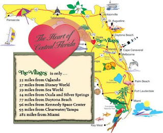
Propaganda Map


As you can see, everything is minutes from the "heart of Florida". These are EXACTLY things will see if you go to that exact spot. I think http://www.thevillagesvideooffer.com/aboutus/images/Florida-map-3-24-04.jpg wants us all to visit. Actually, this is a fun state, but maps like this are a little over the top because they have to be. Without attracting tourism there would not be revenue.

Hypsometric map


This is the "Lincoln/Lafayette trail. Notice the elevation lines! This was my most favorite hike EVER! I could not walk for a week afterwards because I was so sore, but it was worth it. Notice the "old man in the Mountain" on the mountain on the other side of the highway? I got a picture of it from the northwest corner of the trail before the old man fell off. I still want to do that hike again! I got this at Trails.com

PLSS

Not all states use the PLSS (Public Land Survey System), as shown. When zoomed in the maps looks like a grid of red lines in squares that are 6X6 miles and made into townships. Getting the picture that I zoom to has been an issue, I will have to come back to this one

Cadastral Map


This is a Cadastral map of the area I live in. The highlighted property is mine, which I share with 26 horses etc. You can see other property lines in the general area which mark property that is owned by other individuals in the area.

Thematic Map

This is a thematic map that has a theme of Native American Indian reservations that I got from http://www.nps.gov/history/nagpra/documents/resmap.htm. There is a plain pattern of distribution.

Topographic Map

This is a topographic map of Mt. Everest that is used for Soviet military strategy. This type of map shows terrain, water, vegetation and roads. It would be ideal for hikers, military or general directions. Delorme puts out large topographic books with all the states represented. I use them all the time.

Tuesday, June 16, 2009

Planimetric


This is a planimetric map of Florida that I found. It is a basic map with no topography given.